The Delaware Water Gap National Recreation Area is an area known for its many beautiful waterfalls. Home to the two tallest waterfalls in Pennsylvania: Raymondskill Falls and Dingmans Falls, along with dozens of smaller waterfalls, some very well known, and some that see few visitors, there are dozens of fantastic hikes and outdoor attractions throughout the area.
In an effort to explore beyond the well-known attractions, I decided to hike the Cliff Park Trails just south of Milford in Pike County, Pennsylvania.
Explore even more little-known waterfalls on the nearby Hornbecks Creek.
The Cliff Park Trails are sandwiched between the edge of downtown Milford to the north and the Raymondskill Falls area to the south. Thousands visit Raymondskill Falls every year without realizing that from that same parking area, you can see some of the best overlooks in the Delaware Water Gap, as well as a beautiful waterfall.
While these trails have been hiked for decades, they were acquired by the National Park Service in 2003. After spending a few years improving them, the trails were officially opened to the public in June 2010. The park has a total of eight, interconnecting trails that add up to about nine miles of hiking.
When planning my hike, I put together a hike with as little backtracking as possible. While the hike is slightly over 6 miles in length, it’s not an overly challenging hike and offers a chance to see the park’s four overlooks and waterfall. It’s worth noting that there were no printed maps available at the trailhead. It’s best to either print your own copy or download it to your phone.
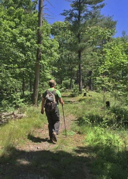
I started my hike from the Cliff Park Trailhead, one of three trailheads in the park. You could also do nearly the same hike starting from the Hackers Trailhead, just across Raymondskill Road from the Raymondskill Falls parking lot.
It’s worth noting that the road to the Cliff Park Trailhead is a bit bumpy and looks more like a private road than a public one. However, my car was able to handle the road without any difficulty. It’s also worth noting that this road up to parking area doesn’t show up on most GPS systems.
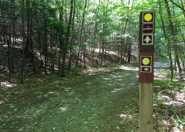
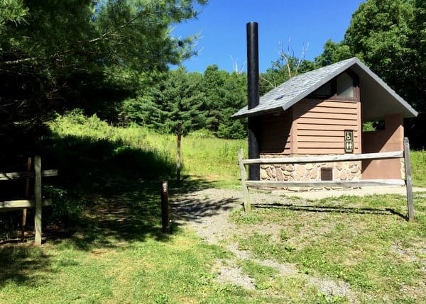
From the parking lot, you can head out in one of two directions. While looking away from the entrance to the lot, I took the trail to the right, past the small wooden bathroom. This is the orange-blazed Buchanan Trail.
This trail winds its way along the edge of field. Like nearly all of the trails here, it is wide and easy to follow. After 4/10 of a mile, take a right onto the yellow-blazed Hackers Trail. This trail is a bit steep in spots, but isn’t too challenging.
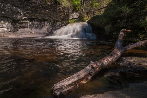
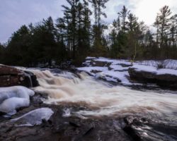
After winding its way through the forest for about half a mile, the trail comes to Hackers Falls. Hackers Falls is only about 10 feet in height, but features imposing cliffs on one side of the falls and is quite powerful. (For those interested in just seeing the waterfall, it can be found at the following coordinates: 41.299296, -74.838528)
This waterfall is located on Raymondskill Creek and is the uppermost waterfall on this creek. All of the other falls, including the tallest waterfall in Pennsylvania, are located downstream of Raymondskill Road.
After enjoying Hackers Falls, continue to follow the Hackers Trail downstream. The trail quickly moves away from the creek and continues through the woods. After about 6/10 of a mile, you’ll come to the yellow and white-blazed Loggers Path. When I visited during the summer of 2016, this trail was rather grown over, though still easy enough to follow.
Being overgrown and steep, this trail is the most challenging portion of this hike, though it’s only 2/10 of a mile in length. Should you rather take an easier route or if you happen to miss the turnoff, you can continue half a mile on the Hackers Trail until you reach the white-blazed Cliff Trail, and turn right on this trail. This will add about 8/10 of a mile to your hike.
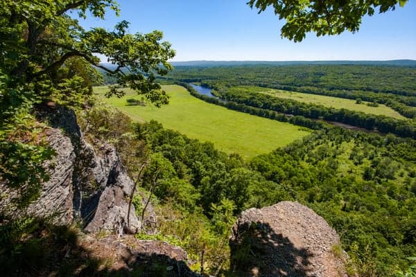
At the end of the Loggers Path, you’ll be at the top of the Raymondskill Ridge. The white-blazed Cliff Trail goes off in both directions. While you’ll want to head to the left eventually, I’d recommend turning right and walking the very short distance to the first overlook: the Tri-State Overlook.
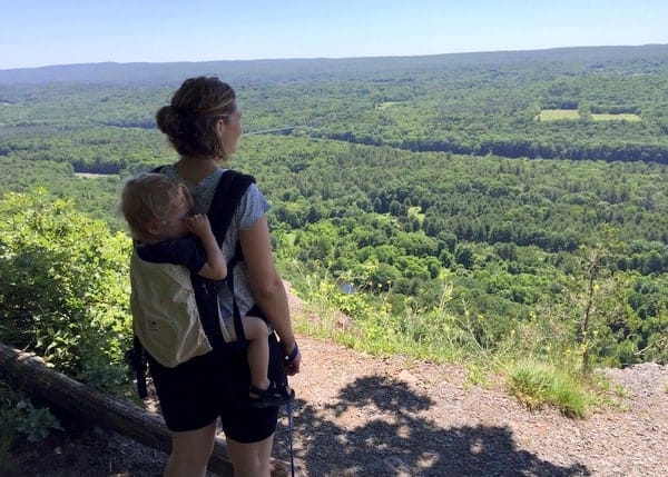
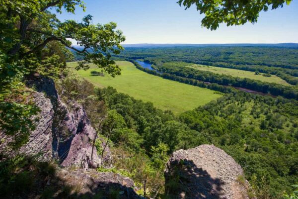
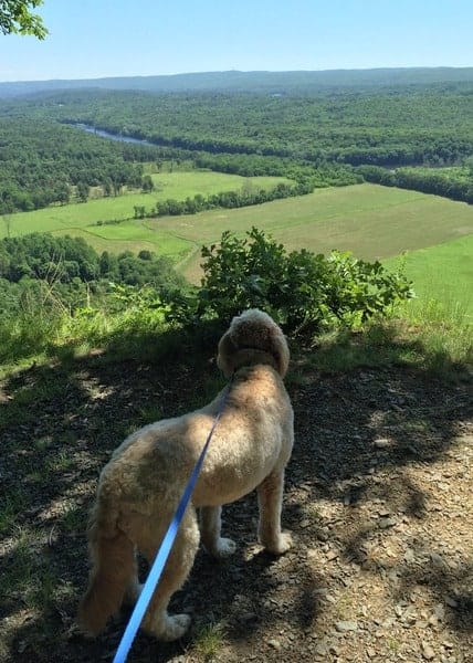
This is the first of four overlooks along the ridge, Each of which offers a very commanding view of the Delaware Water Gap far below. As the name implies, it is possible to see three states (Pennsylvania, New Jersey, and New York) from here, though I believe the same could be said of all the overlooks.
Turning back onto the Cliff Trail, retrace your steps back to the Logger Path, and then continue to follow the Cliff Trail for the next two miles. Along the way, you’ll pass the Minisink Overlook and the River Overlook. Both of these vistas offer great places from which to view the valley below.
Towards the end of the Cliff Trail, it crosses over some short, but steep hills before eventually dead ending at Milford Knob.
Milford Knob offers an amazing vista overlooking downtown Milford and Pennsylvania Route 6. It’s amazing to have such a great view looking directly over this community. It’s rare to see a town from such a vantage point without being in an airplane or helicopter.

After soaking in the view, turn around and head back down the Cliff Trail. After about 1.5 miles, you’ll come back to the orange-blazed Buchanan Trail to your right. Head down this trail for a short distance. While this trail will take you back to your car, you can also hop on either of the blue-blazed Pond Loop trails that you see. These trails are a bit shorter and don’t require backtracking along the Buchanan Trail.
The Cliff Park Trail System is one of the hidden gems of the Delaware Water Gap National Recreation Area. Hiking here gives you the chance to enjoy some of the area’s quieter places, see some great overlooks, and even a beautiful waterfall.
Those looking for shorter hikes can simply turn around at Hackers Falls for a two mile hike. You can also park at the Milford Knob Trailhead and take the three-mile trip up and back the steep trail to that overlook. However, with so much to see in the full 6.2-mile loop, there’s no reason to not fully explore the amazing Cliff Park Trail System.
The parking area for the Cliff Park Trailhead is located at the following coordinates: 41.303776, -74.832831. Note that your GPS might not have the road that connects the 1,500 feet from Cliff Park Road to the parking area.
For more information, visit the trail system’s page or check out this great map made by the park service.
[Click here for information on how to use the coordinates in this article to find your destination.]
 "
"


Great blog post! I’m planning to hike this trail. Would a young child (age 6) be able to hike it? And how long did it take to complete the 6 mile hike?
It’s not an especially difficult hike overall. Just a few steep places. So, it would depend if the child could hike that far. As for time, I’m a bad person to ask because I always take forever taking photos.
Just wanted to add a wonderful update. A new trail has been established by the park service that connects the Milford Knob with the town of Milford. You can park at the foot of the new Mott Street Bridge that crosses the Sawkill Creek. The trail starts on the other side of the bridge and winds along the unspoiled banks of the creek before switchbacking up the hill towards the Knob. The hike is a joy with many beautiful new vistas but most importantly it makes it possible to enter this amazing trail system directly from the town without first driving to a trail head.
on historical sites : there are old remains of buildings in Knox.Pa. where they used to have a foundry that made cannonballs. not mush to actually see ;just standing mason works.