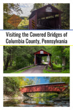
If you love Pennsylvania’s historic covered bridges, Columbia County is a great place to head. That’s because the county is home to 21 historic covered bridges. In the state, only Lancaster County and Washington County have more.
These bridges are located throughout the county with 12 located north of the Susquehanna River and nine to the south of the river. This means that no matter where you are in the county, you aren’t too far from one of the beautiful covered bridges in Columbia County, PA.
To help you visit them and to learn more about their history, I’ve listed all of them below, along with photos, information, and parking details for each. They are broken into five groups: Northwestern Bridges, Northeastern Bridges, Central Bridges, South-Central Bridges, and Southern Bridges.
Within each region, the bridges are listed in an order that makes sense when visiting them. You can also just as easily do each region in the opposite direction or connect multiple regions together if you want to see even more of Columbia County’s covered bridges.
[Click here for information about how to use the coordinates in this article to find your destination.]
Northwestern Columbia County Covered Bridges
These four bridges are located near Route 42, close to the border with Lycoming County (which is home to three covered bridges of its own).
The bridges below are listed from the southernmost to the northernmost. Coincidentally, they are also listed from west to east. That means that you can very easily visit the bridges either in the order listed or in the opposite order.
Shoemaker Covered Bridge
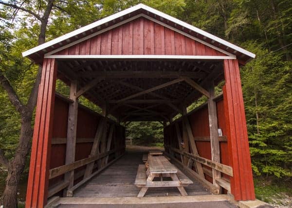
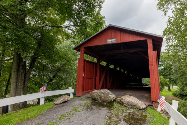
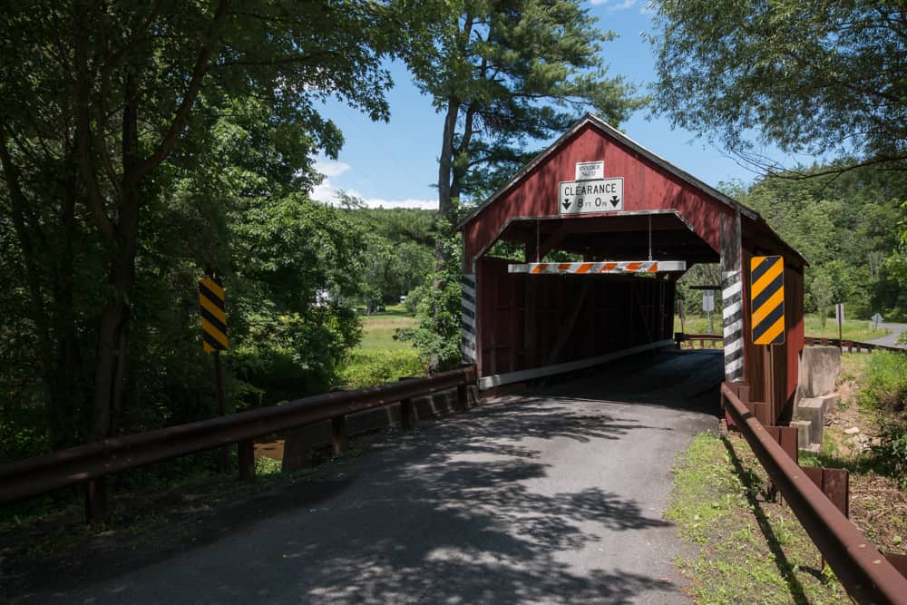
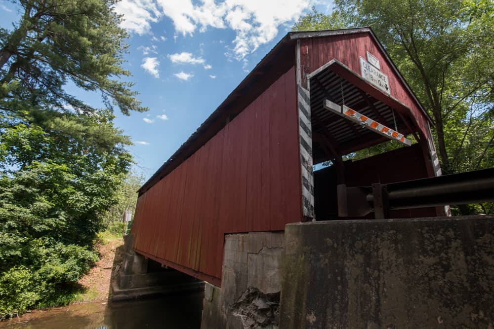
Shoemaker Covered Bridge is located just off of Route 442 in Pine Township. This bridge is 49 feet long and crosses over West Branch Run. It was designed using the Queen post truss and was built in 1881.
Shoemaker Covered Bridge was rehabilitated in 2008, but now only carries foot traffic. A few picnic tables have been set up inside the bridge. Unfortunately, at the time of my visit, a large road sign was blocking the bridge to traffic.
Hopefully, in the future, a less obtrusive design will be used.
Getting There: Shoemaker Covered Bridge is located just a short distance from the intersection of Route 42 and 442. It can be found at the following coordinates: 41.151372, -76.536121.
Parking here is easy enough, as long as there is no one else at the bridge. Simply go until the end of the road and park your car. Note that there is a house directly next to the bridge. Do not block their driveway or walk on their property when visiting Shoemaker Covered Bridge.
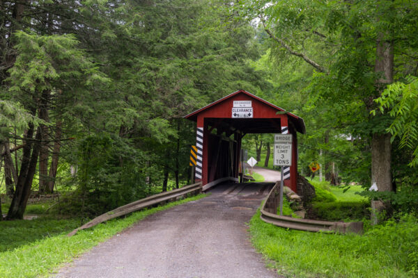
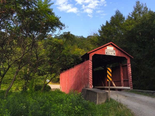
Sam Eckman Covered Bridge
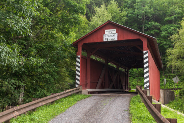
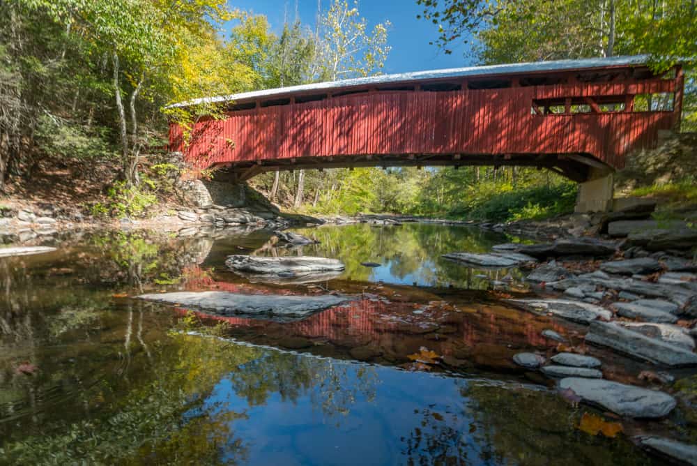
Sam Eckman Covered Bridge was built in 1876 and also uses a Queen post truss. It is the furthest downstream of the three covered bridges to cross Little Fishing Creek and is 66 feet long.
This covered bridge was built in 1876 is and named after a local farmer, Sam Eckman. It is located in a very beautiful part of Columbia County, with one side of the bridge facing the forest and the opposite side facing open farmland.
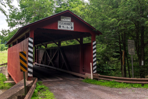
Getting There: Sam Eckman Covered Bridge is located 2.5 miles off of Route 42. It can be found at the following coordinates: 41.177478, -76.490308.
To park at the bridge, simply find somewhere wide enough to pull off to the side of the road.
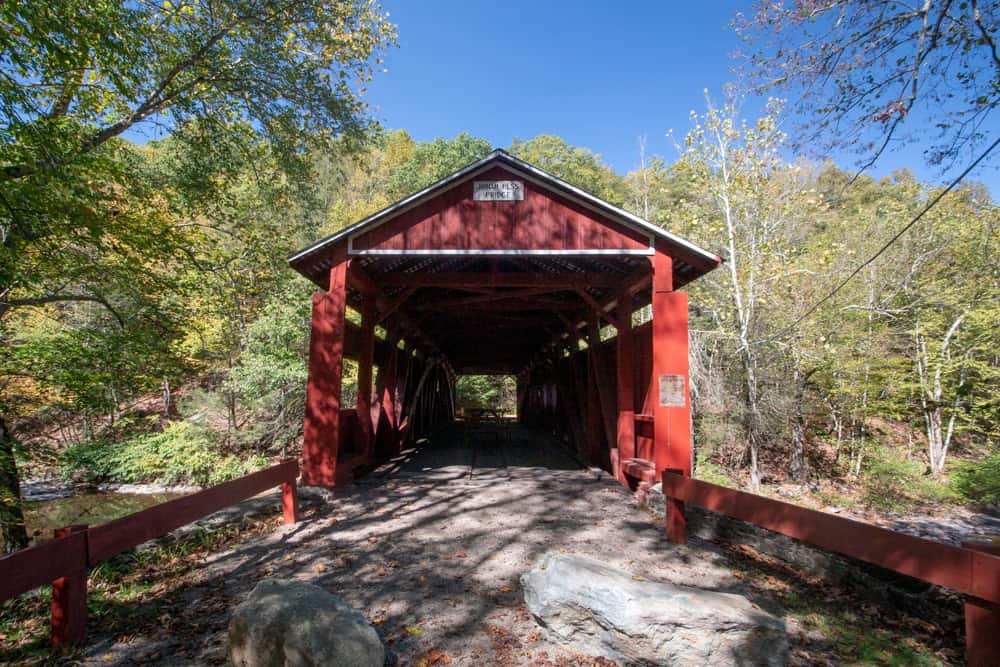
Jud Christian Covered Bridge

Jud Christian Covered Bridge (sometimes called Jud Christie Covered Bridge) is the second covered bridge on this list that crosses Little Fishing Creek. It is 55 feet long and was built in 1876 using Queen post trusses.
It was named after Jud Christian, a local lumberman and farmer.
When I visited the bridge, it was undergoing some major repair work. By the time this article is published, the work should have been finished. I can’t wait to revisit this bridge to get some better photos of it.
Getting There: Just like Sam Eckman Covered Bridge, Jud Christian Covered Bridge is located just off of Sereno Hollow Road. It can be found at the following coordinates: 41.195912, -76.473029.
I don’t recommend approaching this road from the south off of Austin Trail as this road is quite narrow and rutted.
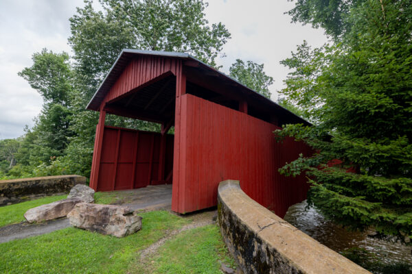
Creasyville Covered Bridge
Creasyville Covered Bridge is the furthest upstream of the three covered bridges that cross Little Fishing Creek. As with the other four bridges in this part of the county, this bridge uses Queen post trusses.
It is 44.5 feet long and was built in 1881.
Of the four bridges in this part of Columbia County, Creasyville Covered Bridge was located in the most beautiful location, being surrounded by beautiful farmland.
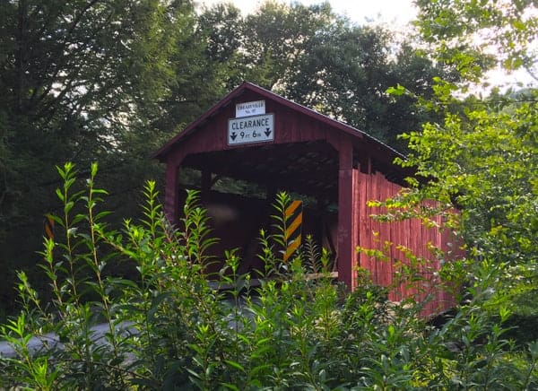
Getting There: Creasyville Covered Bridge is located in a narrow valley roughly 4.5 miles south of Route 118. It can be found at the following coordinates: 41.212338, -76.461399.
There is ample room for cars to pull off at this bridge. However, make sure that you don’t block the driveway of the nearby house when you park.
Northeastern Columbia County Covered Bridges
Northerneastern Columbia County is home to six covered bridges. Five of these bridges are located near Route 487. In fact, if you are driving from Route 11 or Interstate 80 to or from Ricketts Glen State Park, you’ll pass within a few hundred yards of three of these bridges.
The sixth bridge is located a decent distance from the county’s other covered bridges, but since it’s only a short distance from Route 11, it isn’t overly difficult to visit.
The bridges here are listed from west to east.
Kramer Covered Bridge

Kramer Covered Bridge is located near Rohrsburg and a short distance from Route 254. It is on a quiet country road surrounded by farmland.
This bridge was built in 1881 and, like many others in the county, utilizes a Queen post truss. It crosses Mud Run just before its confluence with Green Creek and is 50 feet in length.
Kramer Covered Bridge was rehabilitated in 2008 and is in great condition. It spans the border with Northumberland County, which is also home to several other covered bridges.
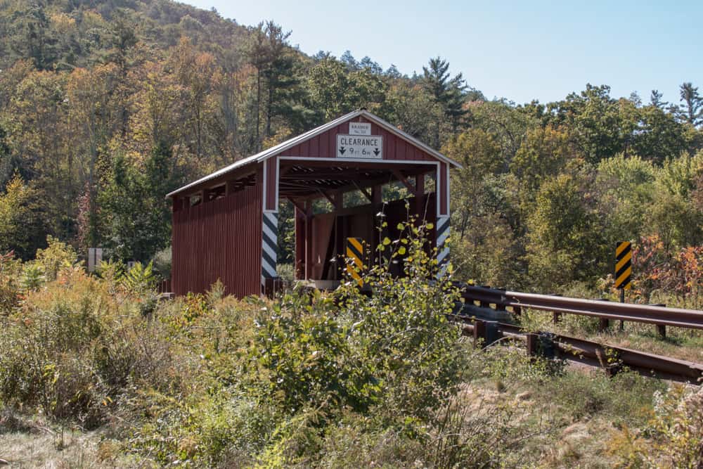
Getting There: Kramer Covered Bridge is located in a rural part of Columbia County and can be found at the following coordinates: 41.121253, -76.432097.
There are several areas to park along the side of Turkey Path Road, with the best option being a large pull off on the southern end of the bridge.
Patterson Covered Bridge
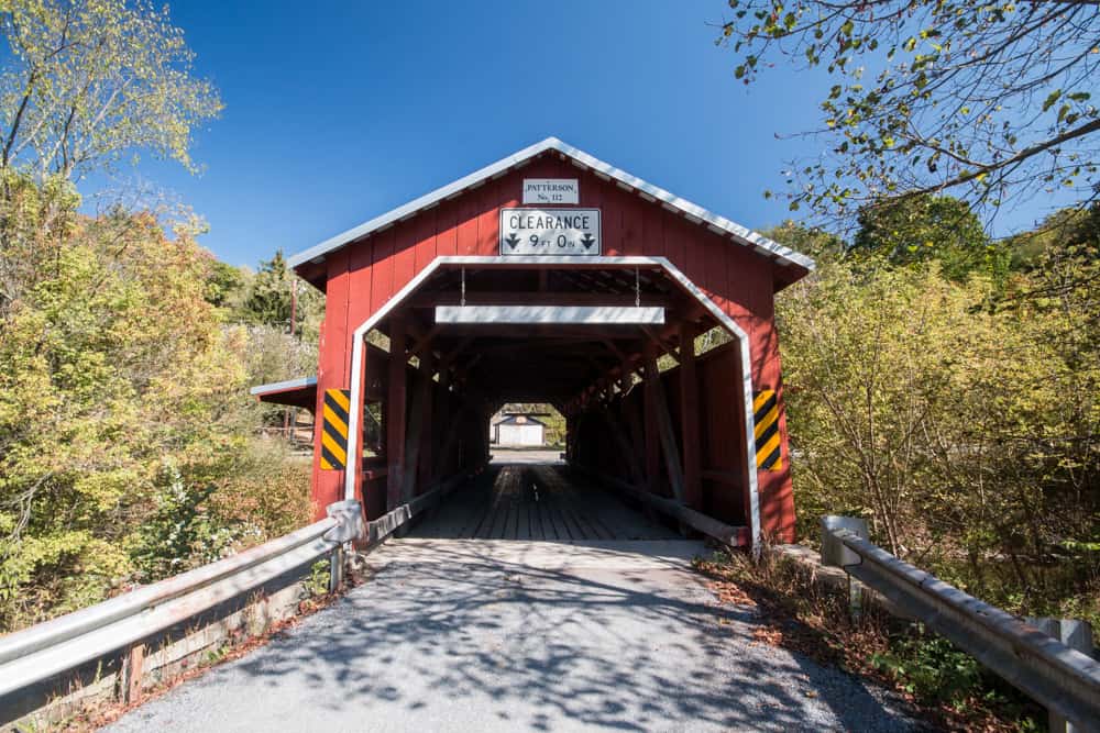
Patterson Covered Bridge is located less than two miles southeast of Kramer Covered Bridge and is just off of Rohrsburg Road.
Built in 1875, it was named after a nearby sawmill which is no longer standing. This bridge was most recently refurbished in 2006.
Patterson Covered Bridge crosses Green Creek downstream of its confluence with Mud Run. It is 82 feet long.
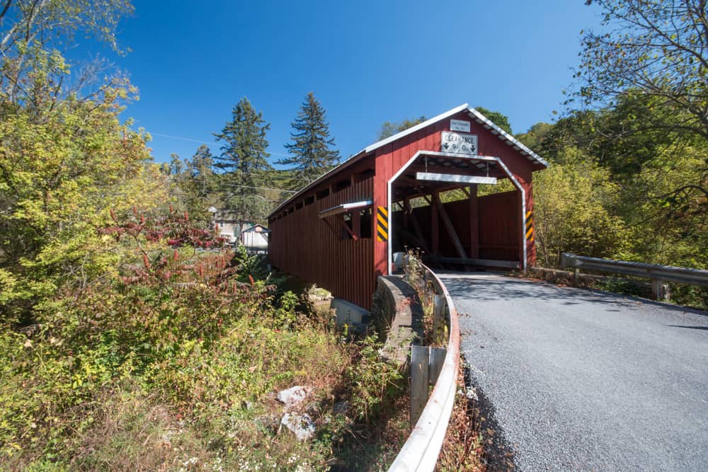
Getting There: Patterson Covered Bridge is located at the intersection of Rohrsburg Road and Hartman Hollow Road. It can be found at the following coordinates: 41.109568, -76.417157.
Since Rohrsburg Road receives a decent amount of traffic, park along Hartman Hollow Road on the western end of the bridge. There is plenty of room for cars to pull off of the road here.
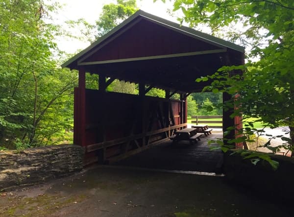
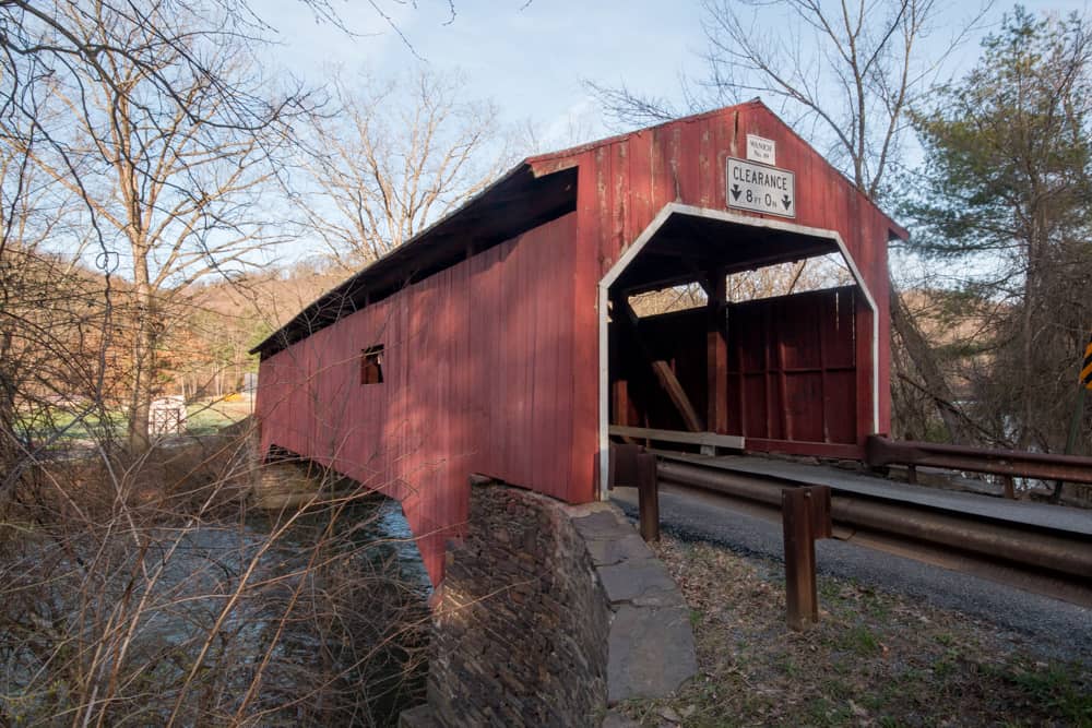
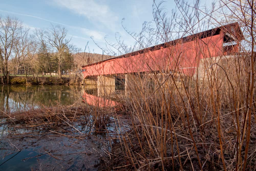
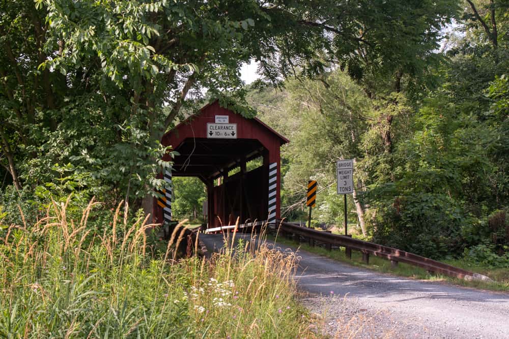
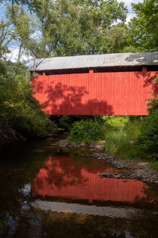
Stillwater Covered Bridge
Stillwater Covered Bridge is located just feet from Route 487 in Stillwater, PA. In fact, if you are driving this busy thoroughfare, you can see the bridge from the main road.
Stillwater Covered Bridge was built in 1849 and is 151 feet long. It is the second oldest and the second-longest of the covered bridges in Columbia County.
This bridge crosses Fishing Creek and is only open to pedestrians.
Getting There: As noted above, Stillwater Covered Bridge sits just off of Route 487. It can be found at the following coordinates: 41.152116, -76.367232.
This bridge is located in an area that is surrounded by houses, which makes it a bit difficult to park while enjoying the bridge. Make sure to find somewhere that doesn’t block any of the driveways of the nearby homes.
East Paden and West Paden Covered Bridges
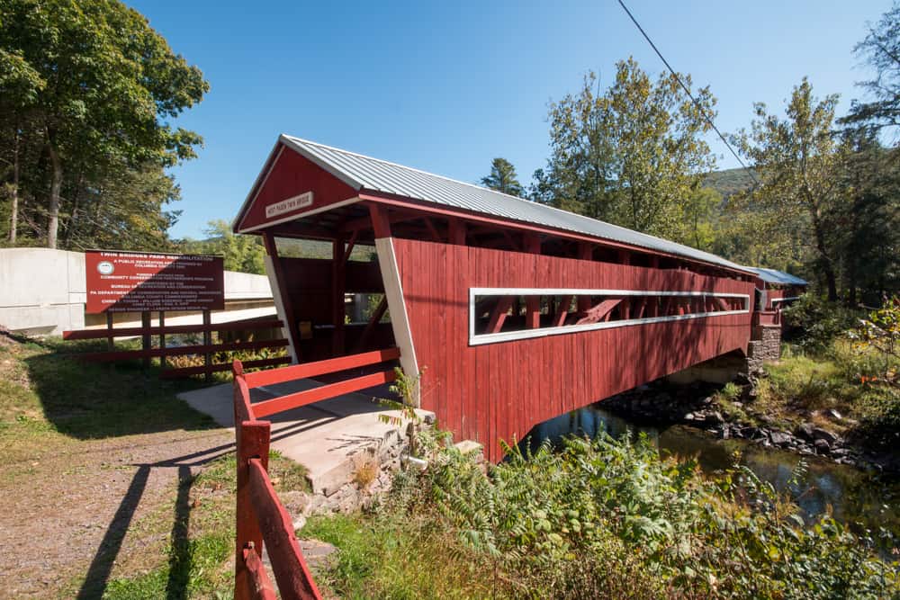
Did you know that Columbia County is home to the only double covered bridges that are still standing in the United States?
Known also as the Twin Bridges, East Paden and West Paden Covered Bridges were constructed in either 1850 or 1884, depending on the source you go with. West Paden Covered Bridge was washed away in a flood in 2006 and was rebuilt in 2008.
I couldn’t find any information to explain why two bridges were constructed here instead of one long one, but I would assume it was easier than creating a single long bridge with one Burr arch truss. The two bridges are connected via an uncovered section over the middle bridge support.
These two bridges cross Huntington Creek. East Paden Covered Bridge is 75 feet long while West Paden Covered Bridge is 112 feet long.
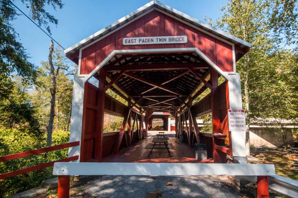
Getting There: The Twin Bridges are located a short distance off of Route 487 north of Orangeville. They can be found at the following coordinates: 41.106541, -76.356459.
These two bridges are located in a small public park and there is ample parking nearby along Twin Bridges Lane.
Josiah Hess Covered Bridge
Josiah Hess Covered Bridge is located only about a mile east of the Twin Bridges and is upstream of them along Huntingdon Creek.
This bridge was built in 1875 and was named after the owner of a nearby sawmill. It is 105 feet in length.
In my opinion, this is one of the most beautiful of Columbia County’s covered bridges. It’s not only located in a nice forested setting, but it’s also easy to get down to creek level and view this bridge from below.
Getting There: Josiah Hess is located just over a mile east of Route 487 along Winding Road. It can be found at the following coordinates: 41.113971, -76.339333.
There is room to carefully pull off to the side of the road along Winding Road to get a closer look at this beautiful spot.
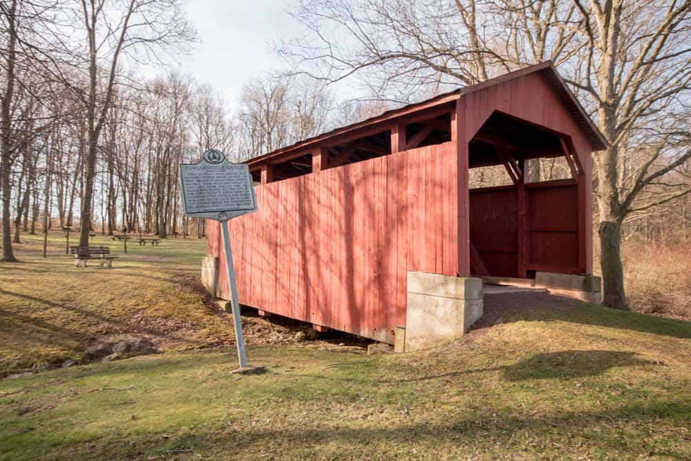
Fowlersville Covered Bridge
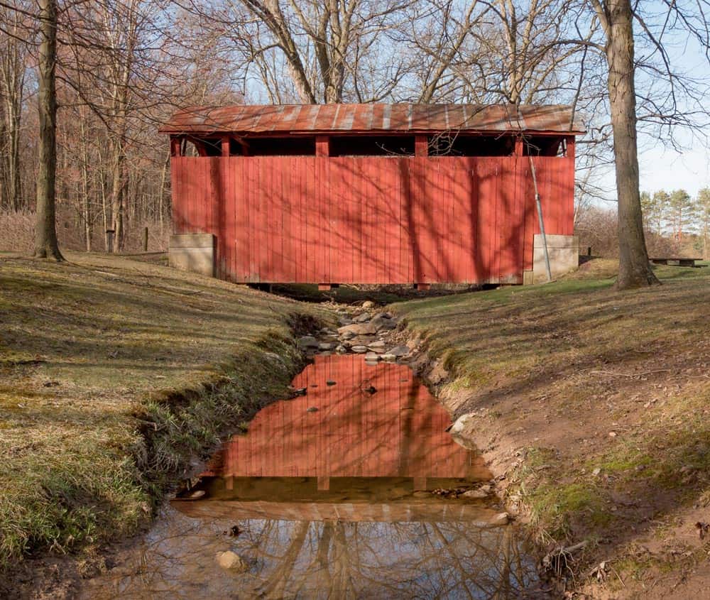
Fowlersville Covered Bridge is located a bit away from the other covered bridges in Columbia County and is just north of Route 11 and near Berwick, PA, home of the popular Berwick Christmas Boulevard and the Stuart Tank Museum. It is the easternmost covered bridge in the county.
This covered bridge is the most recently constructed of the county’s covered bridges (It was built in 1886) and is the shortest still-standing covered bridge in the county at only 40 feet in length.
It originally crossed the West Branch of Briar Creek. However, in 1986, it was moved to Briar Creek Lake Park. Today, it sits in a back corner of the park and crosses a small drainage ditch. Nevertheless, it’s in a quite beautiful setting within the park.
Getting There: Fowlersville Covered Bridge is located in the southwestern corner of Briar Creek Lake Park near Bill’s Old Bike Barn and Berwick, PA. It can be found at the following coordinates: 41.060923, -76.283492.
There is a large dirt pull-off near the bridge that serves as a good parking area for those that want to see the bridge. Note that the park is only open from dawn until dusk.
Central Columbia County Covered Bridges
There are three covered bridges in central Columbia County, all of which are located only a short drive from Bloomsburg. Of these, two are located north of the Susquehanna River and one is located south of the river.
They are listed here from north to south and are easy bridges to visit whether you are doing a covered bridge road trip or simply looking for something to see near Route 11 in Bloomsburg.
Wanich Covered Bridge
Wanich Covered Bridge is located a short distance north of Bloomsburg along Route 42.
While some sources say Wanich Covered Bridge was built in 1844, which would make it the oldest covered bridge in Columbia County, it was more likely built in 1884. It has obviously be rehabilitated over the years as it continues to be in great shape.
This bridge crosses Little Fishing Creek a good deal downstream of three of the covered bridges in northwestern Columbia County that cross the same waterway. It is 98 feet long.

Getting There: Wanich Covered Bridge is located on Covered Bridge Drive just off of Route 42. It can be found at the following coordinates: 41.039964, -76.483420.
There is room to pull off of the road on the eastern side of the bridge where Covered Bridge Drive meets Thomas Road.
Rupert Covered Bridge

Located on a short distance south of town, Rupert Covered Bridge is the closest covered bridge to Bloomsburg, Pennsylvania.
This bridge crosses Fishing Creek only about half a mile north of where it meets the Susquehanna River. Because of the width of the waterway at this point, Rupert Covered Bridge is 185 feet in length, making it the longest covered bridge in Columbia County and one of the longest in all of Pennsylvania.
This bridge is located adjacent to two railroad bridges, which add a unique look to this spot. If you’re lucky, you might even have a chance to see a train and a covered bridge at the same time.
Getting There: Rupert Covered Bridge is located on the edge of a residential area just south of Bloomsburg. It can be found at the following coordinates: 40.981278, -76.472583.
Parking here is quite easy. There is a large paved lot on the far side of the train trains on the bridges western end. There is also a large dirt pull-off on the eastern end that has a sign with some historical information about the bridge.
Hollingshead Covered Bridge
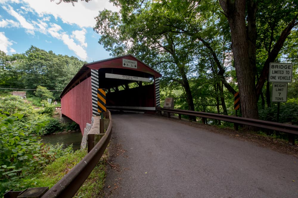
Hollingshead Covered Bridge is the northernmost bridge in Columbia County that’s south of the Susquehanna River. It is located only a short drive from the unusual Hooded Grave Cemetery.
This covered bridge spans the Catawissa Creek just over a mile from its confluence with the river. It is 116 feet in length.
Hollingshead Covered Bridge was constructed in the early 1850s and was named after a local mill owner. It was rehabilitated in 1999.
Getting There: Hollingshead Covered Bridge is located just outside of Catawissa, PA, and can be found at the following coordinates: 40.951824, -76.447662.
For those looking to get out and enjoy the bridge, there is a bit of room to pull off of the road along Mountain Road.
South-Central Columbia County Covered Bridges
There are four covered bridges in south-central Columbia County. These bridges are all located near Routes 487 and 42 and near the community of Slabtown.
They are listed from east to west.
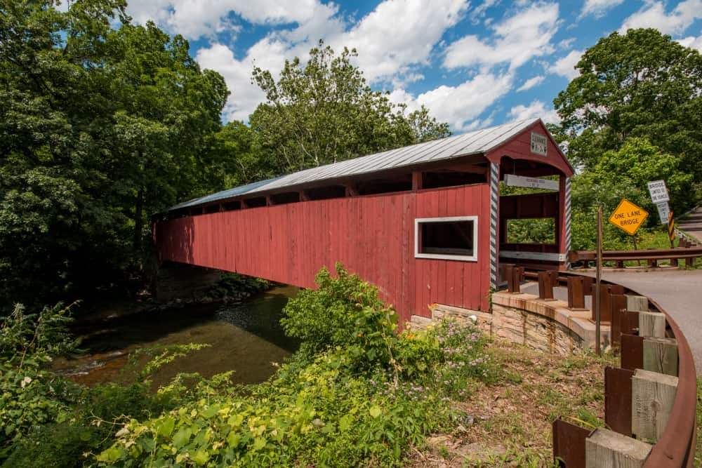
Snyder Covered Bridge
Snyder Covered Bridge is the furthest upstream of the four covered bridges that cross Roaring Creek. It is also the only one in south-central Columbia County that is east of Route 42.
This covered bridge is only 60 feet long, making it one of the shortest covered bridges in the county. It was originally constructed in either 1860 or 1876, depending on which source you believe.
The bridge is located at a narrow dip in the landscape and is surrounded by trees, which add a lot of beauty to the area.
Getting There: Snyder Covered Bridge is located near Slabtown and Numidia in southern Columbia County. It can be found at the following coordinates: 40.901261, -76.394471.
There is room to pull off to the side of the road on both ends of the bridge.
Davis Covered Bridge
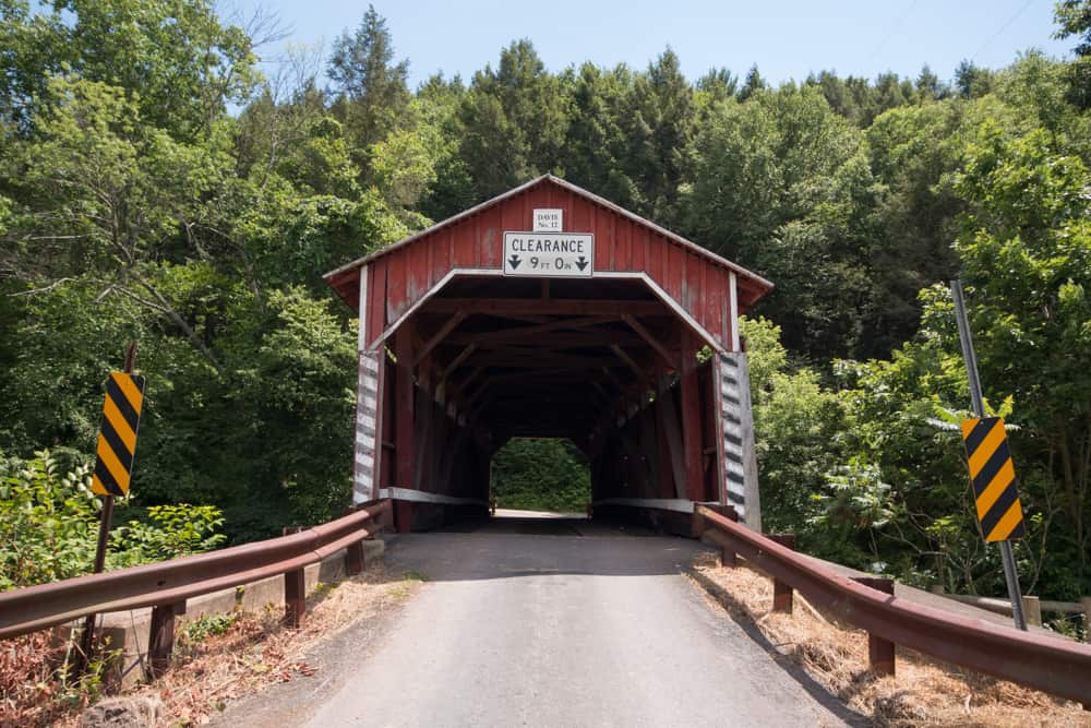
Davis Covered Bridge is located just west of Route 42. Like the other bridges in south-central Columbia County, it crosses Roaring Creek near Queen City.
Depending on which source you believe, this bridge was either constructed in 1850 or 1875. It is 87 feet long.
This bridge is located next to both a beautiful forest and some scenic farmland, making this a great spot to visit if you love beautiful covered bridges.
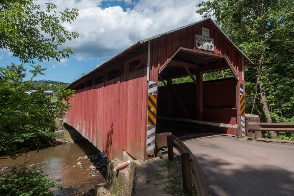
Getting There: Davis Covered Bridge near Queen City, PA and is just west of Route 42. It can be found at the following coordinates: 40.910256, -76.439834.
There is room to pull off to the side of the road along Shakespeare Road to the north of the bridge.
Esther Furnace Covered Bridge
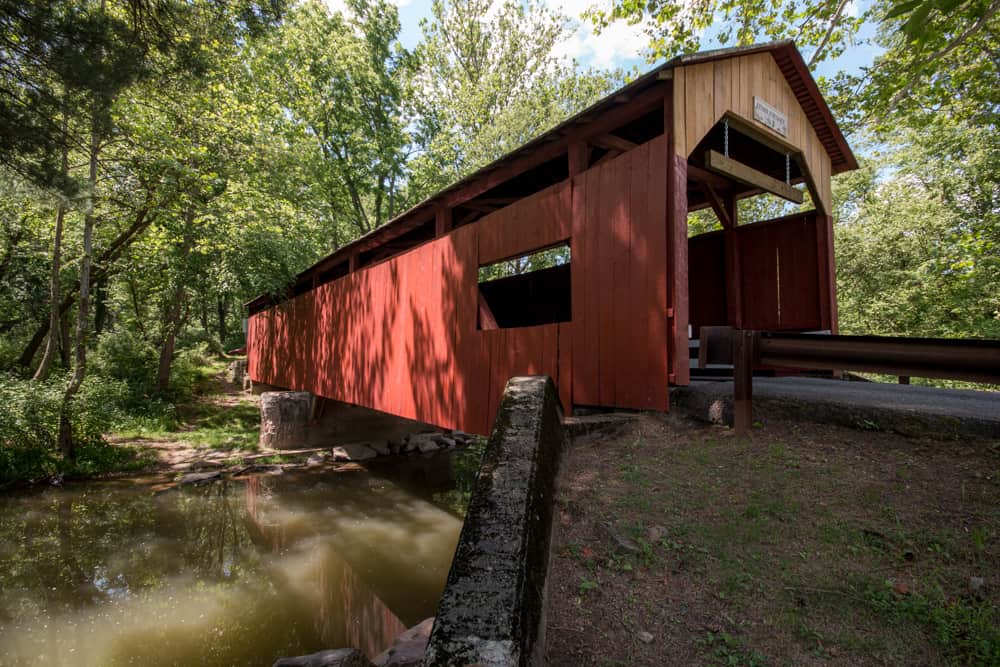
Esther Furnace Covered Bridge is the third of four covered bridges along Roaring Creek. It is located just over a mile from Davis Covered Bridge and is on the edge of the Lake Glory Campground
This covered bridge was constructed in 1881 and was named after a nearby iron furnace.
This bridge is 101 feet long and has the distinction of being the only two-span covered bridge in Columbia County (not counting the Twin Bridges). It utilizes a Queen post truss with a mid-bridge support.
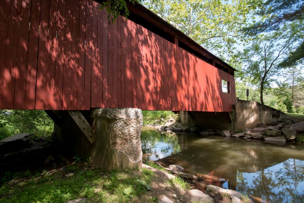
Getting There: Esther Furnace Covered Bridge is on Esther Furnace Road near Lake Glory. It can be found at the following coordinates: 40.906729, -76.459798.
For parking, there is a spot to pull over onto the side of the road on the western end of the bridge. Make sure to avoid parking on the campground’s property or driving along their roads to reach this bridge.
Parr’s Mill Covered Bridge
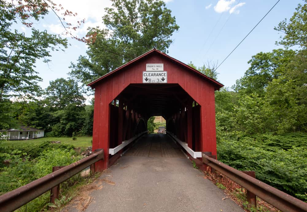
Parr’s Mill Covered Bridge is located just east of Route 487 and crosses Roaring Creek. It is less than a mile from Esther Furnace Covered Bridge.
The bridge was built in 1866 and was rehabilitated in 2012. It was named after a local mill and is 84 feet long.
Parr’s Mill Covered Bridge is one the hardest covered bridges in the county to access as the area around it is somewhat closed off, especially when approaching from the south. It’s a beautiful bridge, though, so hopefully, this will be fixed in the future.

Getting There: Parr’s Mill Covered Bridge is located just off of Ashton Hollow Road at the following coordinates: 40.906409, -76.472636.
Note that it is on Parr’s Mill Road, which is located on both sides of the bridge, but this bridge no longer carries cars across the creek. It is best to approach the bridge from Ashton Hollow Road as the other side has a large dirt pile preventing access.
There is a bit of room to pull off the road on the northern end of the bridge.
Southwestern Columbia County Covered Bridges
There are four covered bridges located in the southwestern part of Columbia County. They are all located east of Elysburg and near the popular Knoebels Amusement Park.
The bridges are listed here from north to south.
Johnson Covered Bridge
Johnson Covered Bridge is located less than a mile east of Knoebel’s in a peaceful part of Columbia County.
Depending on the source that you believe, this bridge is either 61 or 66 feet in length. It crosses Mugser Run.
While most bridges were named after local mills, this bridge was actually named after the owner of a shoe store near the bridge.
Getting There: Johnson Covered Bridge is located just off of Pine Swamp Road in an area bordered by trees and fields. It can be found at the following coordinates: 40.878059, -76.483502.
There is a bit of room to pull off of the road on both sides of the bridge.
Lawrence L. Knoebel Covered Bridge
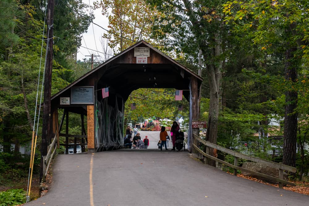
Lawrence L Knoebel Covered Bridge is unique in that it is actually located on the grounds of an amusement park. Fortunately, Knoebels is free to visit, so there is no charge to visit this covered bridge.
The bridge was originally constructed in 1881 over West Creek, 50 miles from its current location. It is 41 feet in length.
This bridge was moved to the park in 1937 and now crosses the South Branch of Roaring Creek. It separates the amusement park from the park’s campground.
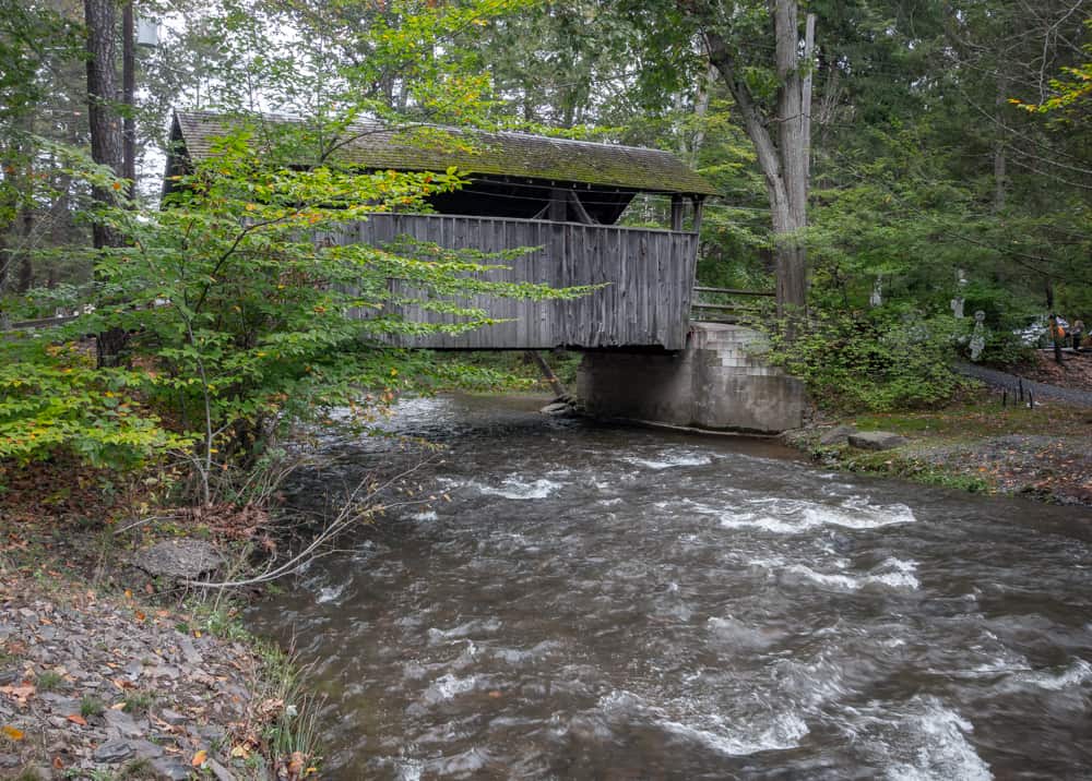
The bridge also features a pedestrian walkway on one side, which I’m assuming was added after it was moved to the park as most historic bridges don’t have this feature.
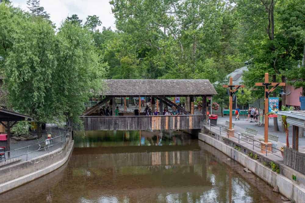
It should be noted that there is a second covered bridge in the park: Knobel’s Grove Covered Bridge. This bridge was built in 1975 and does feature an authentic truss system.
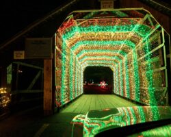
It’s worth taking a minute to see this second bridge while walking through the park. Or, visit during the holiday season to see it lit up on the course for Joy Through the Grove.
Getting There: Since Lawrence L. Knoebel Covered Bridge is located within the park, you’ll have to park in their parking lots (which are free) and walk a bit of distance to get to the bridge. Once at the park, the bridge can be found at the following coordinates: 40.877177, -76.505289.
If you also want to see Knoebel’s Grove Covered Bridge, it can be found here: 40.878972, -76.503890.
Richards Covered Bridge
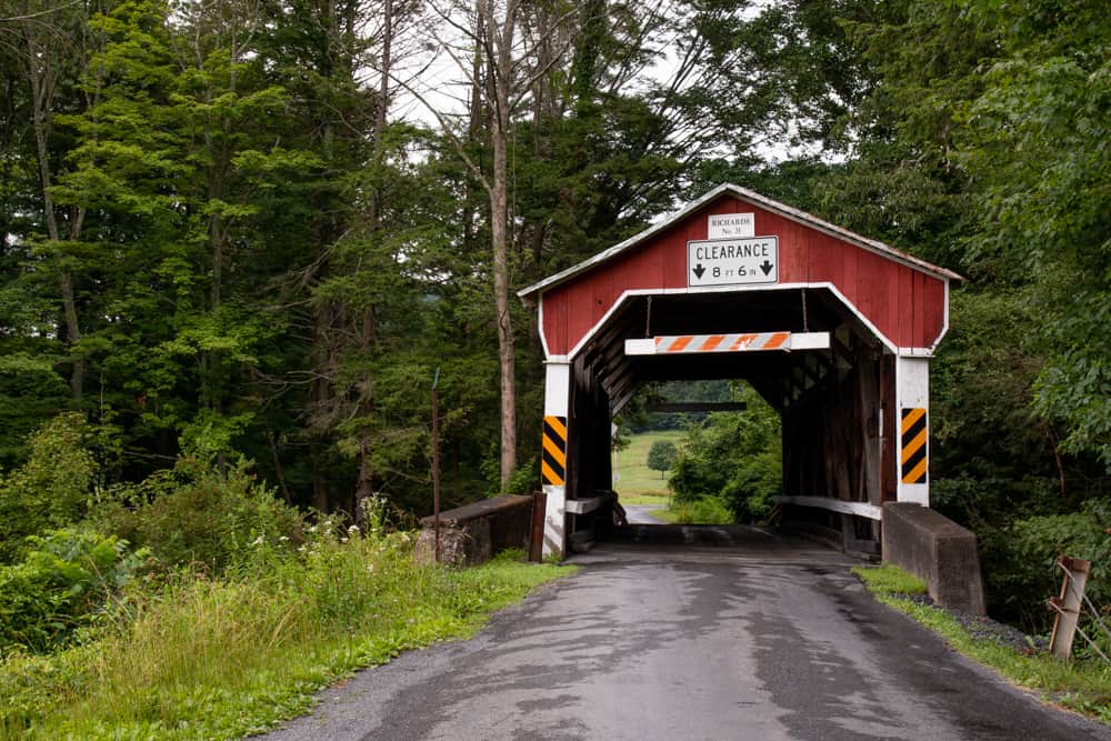
Richards Covered Bridge is located about a mile south of Knoebel’s in a forest part of southern Columbia County.
Like Lawrence L. Knoebel’s Covered Bridge, it crosses the South Branch of Roaring Creek. It is either 64 or 69 feet long, depending on the source that you believe.
Richards Covered Bridge was built in 1880 and was named after a local farmer. Today, the southwestern end of the bridge is on the edge of Knoebel’s golf course.
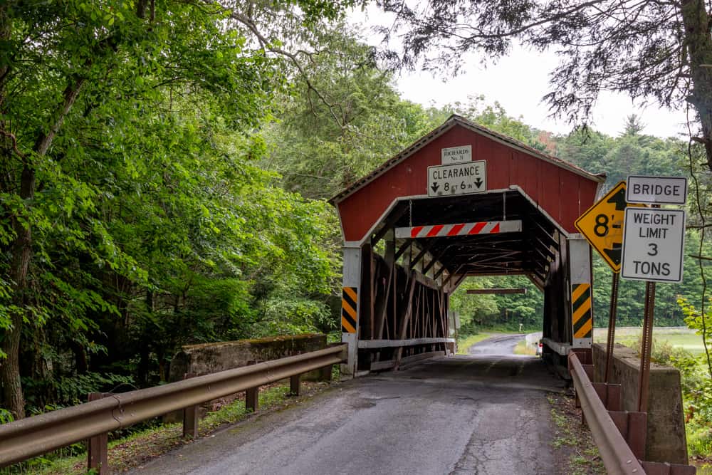
Getting There: Richards Covered Bridge is located on Jepko Road just south of Knoebels Amusement Park. It can be found at the following coordinates: 40.867460, -76.508067.
There is a bit of room to park on the southwestern end of the bridge but make sure to stay away from the golf course.
Krickbaum Covered Bridge
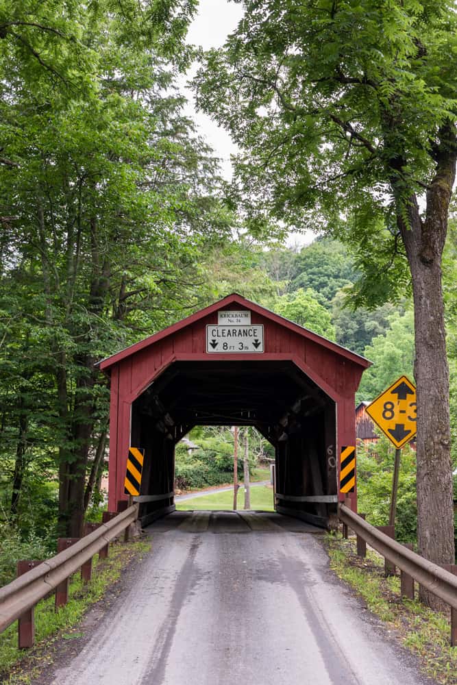
Krickbaum Covered Bridge is the southernmost covered bridge in Columbia County, PA.
Also known as Kreigbaum Covered Bridge, this bridge was constructed in 1876 and crosses the South Branch of Roaring Creek.
Krickbaum Covered Bridge is 62 feet long and is named after a grist mill that once stood nearby.
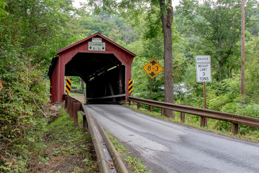
Getting There: Krickbaum Covered Bridge is located a short distance north of Bear Gap, PA. If can be found at the following coordinates: 40.847446, -76.507523.
Parking here is a bit tricky, but there’s a bit of room to pull off to the side of the road along All Saints Road.
Looking for more places to visit nearby? Check out Centralia, Pioneer Tunnel Coal Mine, and the covered bridges of Montour County, PA.
[Click here for information about how to use the coordinates in this article to find your destination.]