
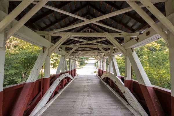
While Somerset County might not be home to the most covered bridges of any county in Pennsylvania, the 10 bridges in the county are some of the most beautiful you’ll find anywhere in the state.
Of these 10 bridges, five are located north of the Pennsylvania Turnpike and five are located south of the turnpike, making it very easy to visit these bridges in one trip or two.
I’ve broken the bridges into two lists that are separated by the Pennsylvania Turnpike. If you were starting in the southwest, near Ohiopyle State Park, you could easily visit all of these covered bridges in the order listed.
The Southern Covered Bridges in Somerset County
There are five historic covered bridges in southern Somerset County. They are listed here roughly from east to west, though they could be visited just as easily in the opposite order.
The bridges in this section include the only covered bridge in PA with a natural waterfall below it.
Lower Humbert Covered Bridge
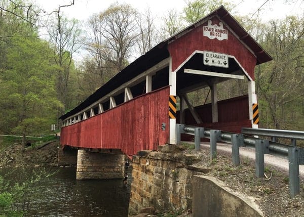
Lower Humbert Covered Bridge is the westernmost and southernmost historic covered bridge in Somerset County, Pennsylvania. This bridge is located only 25 minutes from Ohiopyle State Park, making it the closest covered bridge to this popular destination. The closest community to the bridge is Confluence, just about 3.5 miles away.
Lower Humbert Covered Bridge (also known as Faidley Bridge) was built in 1891 and extensively rehabilitated in 1991. It crosses 126 feet over Laurel Hill Creek, the furthest downstream of the three covered bridges that cross this creek. Thanks to the rehabilitation in 1991, the bridge is still open to vehicular traffic.
Getting There: Lower Humbert Covered Bridge is located in western Somerset County, a few miles from Confluence, Pennsylvania. The bridge is located on a rural road off Route 281. The bridge can be found at the following coordinates: 39.840138, -79.323077.
There is room for several cars to pull off directly across from the bridge along Humbert Road.
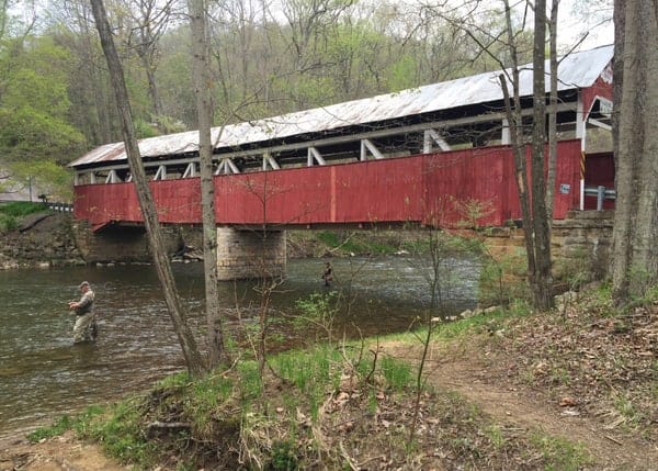
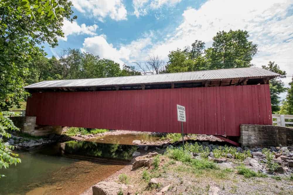
Barronvale Covered Bridge
Barronvale Covered Bridge is the furthest upstream of the three historic covered bridges that cross Laurel Hill Creek (along which you’ll find the Hemlock Trail Natural Area further upstream). At 162 feet in length, it is the longest of the 10 covered bridges in Somerset County, Pennsylvania.
There is a bit of a dispute about the construction date for this bridge. A sign on the bridge says it was constructed in 1830, but that is unlikely as it would predate the settlement of the area. Another date floated is 1846, but it is more likely that the bridge was built in 1902. Today, the bridge is in great condition and is one of the most beautiful covered bridges in PA.
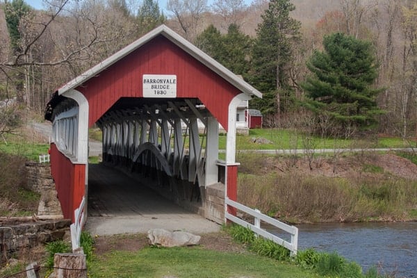
It’s worth noting that this bridge is privately owned, though visitors are allowed to check out the bridge and walk around it. Please respect the property so that this arrangement continues to exist.
Getting There: Barronvale Covered Bridge is one of the most remote covered bridges in the state and isn’t located near any large communities. It is, however, located just a few miles from Cole Run Falls, which makes a worthwhile detour.
Barronvale Covered Bridge can be found at the following coordinates: 39.952746, -79.270497. There is an area to pull off along Ream Road on the western bank of Laurel Hill Creek.
King’s Covered Bridge
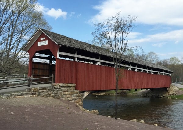
Located just a few minutes from Barronvale Covered Bridge is King’s Covered Bridge. Like Barronvale, this bridge also crosses Laurel Hill Creek, and despite the road being rerouted to a modern bridge, it has been preserved for posterity.
King’s Covered Bridge was likely built in 1906, though some sites list 1802 or 1806 as the construction date. However, as previously discussed, these dates are highly unlikely. This covered bridge is 127 feet in length.
This bridge should not be confused with King Covered Bridge in Greene County, PA.
Getting There: King’s Covered Bridge is located only about a mile south of Barronvale Covered Bridge. It can be found at the following coordinates: 39.937631, -79.271248.
There is a large parking area located next to the bridge and some signage explaining the history and nature of the area.
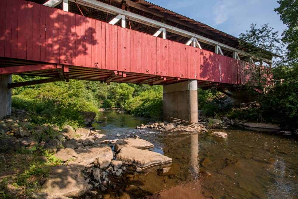
Burkholder Covered Bridge
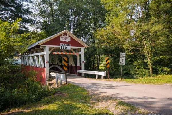
Burkholder Covered Bridge (also known as Beechdale Covered Bridge) is located just off of Route 219 between Garrett and Berlin. Built in 1870, this bridge crosses Buffalo Creek and is 52 feet in length.
Unlike many other covered bridges in Pennsylvania, this bridge has low walls and open sides, offering a great look along Buffalo Creek while crossing the bridge. This bridge is in great shape and still allows traffic. It was last rehabilitated in the early 1990s.
Getting There: Burkholder Covered Bridge is located just a few yards off of Route 219, a major thoroughfare through this part of the state. The bridge can be found at the following coordinates: 39.881800, -79.034578.
There are several places to pull off to the side of Burkholder Bridge Road near the covered bridge.
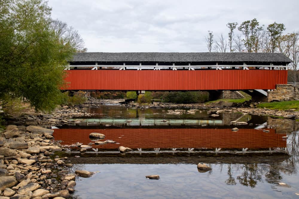
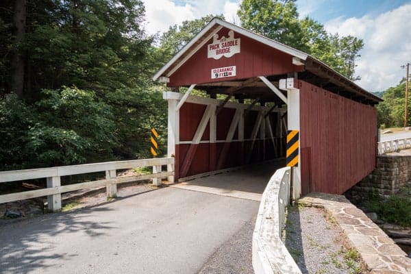
Packsaddle Covered Bridge
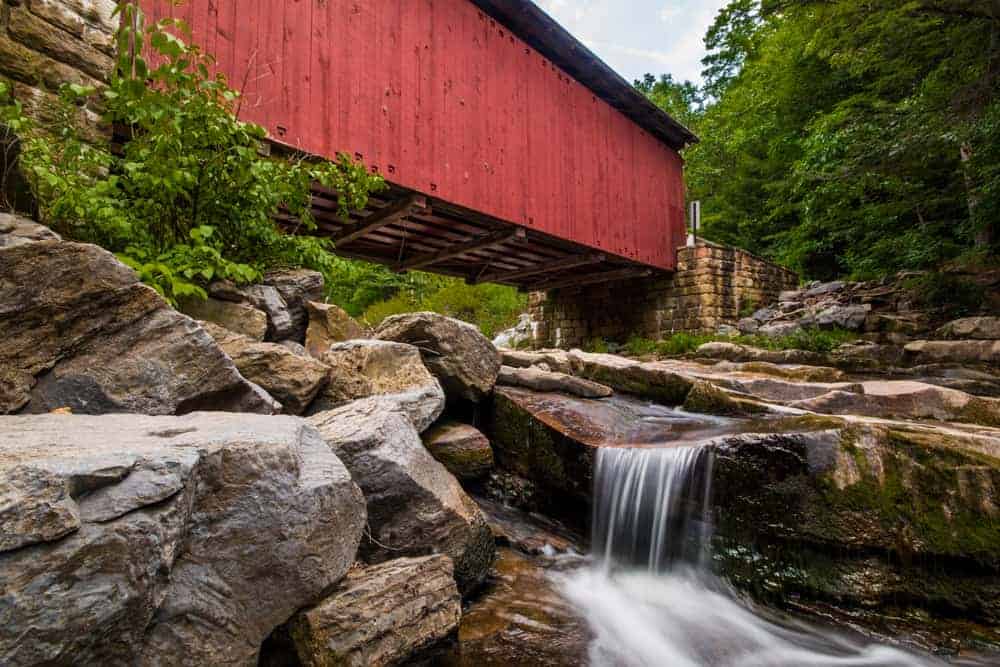
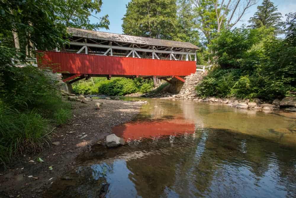
Of all the covered bridges in Pennsylvania, Packsaddle Covered Bridge is easily one of my favorites. This is because it’s the only bridge in Pennsylvania with a waterfall directly underneath the bridge. This creates one of the most idyllic scenes I’ve come across in my travels.
Packsaddle Covered Bridge is the shortest Somerset County covered bridge at only 48 feet in length. It was built in 1870 and still carries traffic over Brush Creek.
The waterfall under Packsaddle Covered Bridge is roughly 10-15 feet in height and falls over a series of drops. The best time to see this bridge is during periods of high water, especially in the spring. This gives the full effect of the waterfall below the bridge.
While you can see the waterfall from the bridge, the best views can be found by carefully walking downstream a bit and looking back up the waterfall and the bridge. Make sure to note which land is posted so as not to accidentally cross onto private property.
Getting There: Packsaddle Covered Bridge is located in a very rural portion of eastern Somerset County, roughly halfway between Routes 219 and 220. The closest major road to the bridge is Route 96. You can find Packsaddle Covered Bridge at the following coordinates: 39.867543, -78.817203.
There is space to park several cars in a pull-off just before reaching the bridge.
The Covered Bridges in Northern Somerset County
The five bridges listed below are all located north of the Pennsylvania Turnpike. They are listed roughly from east to west in an order that would make sense if you wanted to see all of the bridges. This connects well to the previously listed bridges if you want to do a whole day of travel through the county.
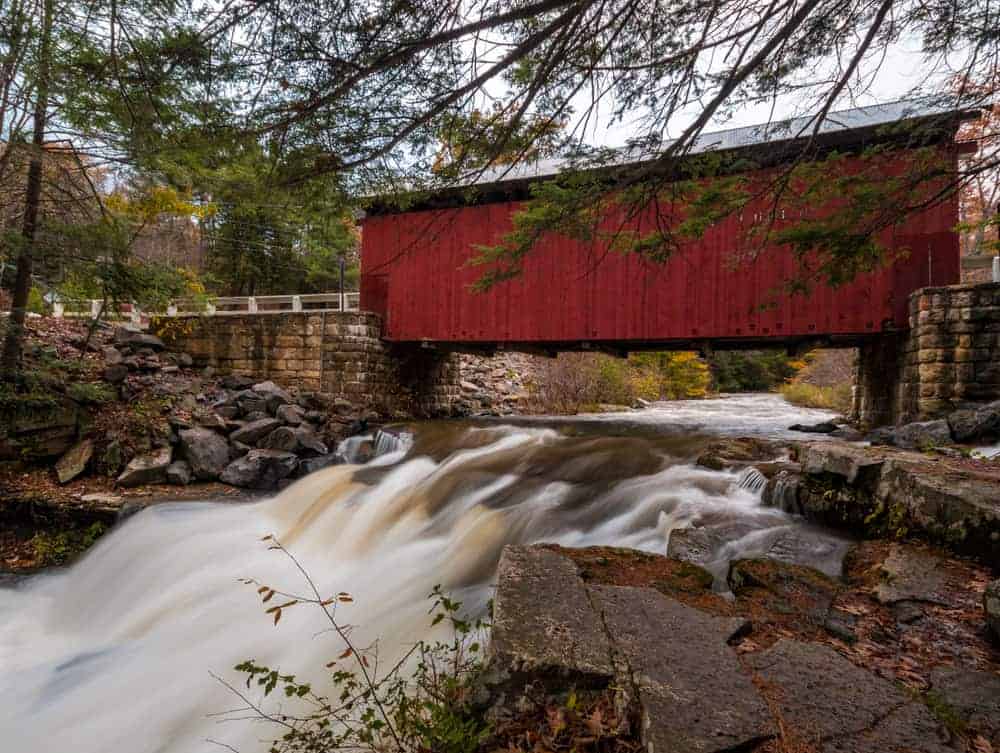
New Baltimore Covered Bridge
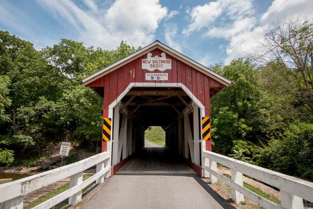
New Baltimore Covered Bridge is the easternmost of the covered bridges in Somerset County, PA. It is located less than a quarter-mile from the Pennsylvania Turnpike, though it’s not near any of the exits. It is also close to some of the covered bridges in Bedford County.
This bridge crosses the Raystown Branch of the Juniata River, the waterway that eventually forms Raystown Lake. It is 86 feet long.
New Baltimore Covered Bridge was originally built in 1879, but it was rebuilt in 1996 after it was destroyed in flooding. Because it’s relatively new construction, this bridge is quite beautiful and well worth taking the time to see.
While some sites list it as a Kingpost truss bridge, the official application put in for the National Register for Historic Places lists it as a Queenpost truss. I’m not sure of the reason for the discrepancy, but it’s something that only covered bridge buffs would likely notice.
Getting There: New Baltimore Covered Bridge is located in the community of New Baltimore in eastern Somerset County. It can be found at the following coordinates: 39.986895, -78.772398.
There is ample room to pull off to the side of the road on the northern side of the bridge for those that want to inspect the bridge more closely.
Glessner Covered Bridge

Glessner Covered Bridge is located near Shanksville, only a short drive from the Flight 93 National Memorial. It is located in a beautiful setting and is one of my favorite covered bridges in Somerset County.
Glessner Covered Bridge was constructed in 1881 and crosses the Stonycreek River. It is 90 feet in length.
This is another bridge where the style of the bridge is listed wrong in some sources. While some sites list it as a Burr arch truss, this is actually a less-common Kingpost truss bridge.
Getting There: Glessner Covered Bridge is located in a rural part of Somerset County along the fittingly named Covered Bridge Road. It can be found at the following coordinates: 40.026164, -78.920860.
There are pull-offs on both sides of the bridge for those that want to park for a few minutes.
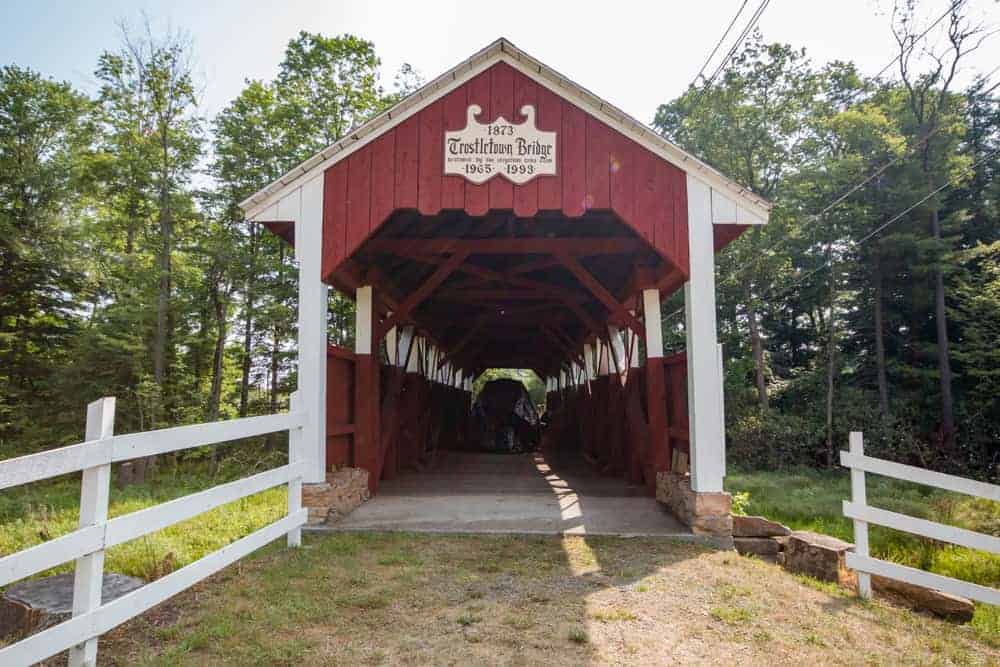
Trostletown Covered Bridge

Trostletown Covered Bridge (also known as Kantner Covered Bridge) is located a short distance off of Route 30 just west of the Flight 93 National Memorial. It is the only covered bridge north of the PA Turnpike in Somerset County that you can’t drive across.
The bridge is said to be open to visitors to walk across but is also used for storage, so that may not be possible. Despite this, this bridge is located in a beautiful setting.
Trostletown Covered Bridge is 104 feet long and crosses over a small stream just before it flows into the Stonycreek River. It was built in 1845 and restored in the middle of the 20th century.
Getting There: Trostletown Covered Bridge is located in Stoystown, PA, less than a quarter-mile from Route 30. It can be found at the following coordinates: 40.096017, -78.945361.
There is a lot of private land around the bridge, but there is room along North Club Road to park while visiting the bridge.
Walter’s Mill Covered Bridge

Walter’s Mill Covered Bridge is located on the grounds of the Somerset Historical Center. The bridge was originally constructed in 1830, though some sources say 1859. If the older date is correct, that would make it one of the oldest covered bridges in Pennsylvania.
When it was built, it was located four miles south of Somerset, PA on Coxes Creek. In the 1960s, the bridge was moved to its current location to save it from destruction. Today, it rests over Haupt creek near a 1700s farmhouse and a historic cider mill.
Walter’s Mill Covered Bridge (also called Cox Creek Covered Bridge in some sources) is 60 feet long and is open to pedestrians.
Getting there: Walter’s Mill Covered Bridge is located on the grounds of the Somerset Historical Center, a nice museum that highlights the history of this part of southwestern Pennsylvania. It can be found at the following coordinates: 40.070988, -79.082835.
For those that would rather have an address, the historical center’s address is 10649 Somerset Pike, Somerset, Pennsylvania 15501.
Park in the center’s parking lot to visit this covered bridge.
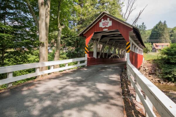
Shaffer’s Covered Bridge
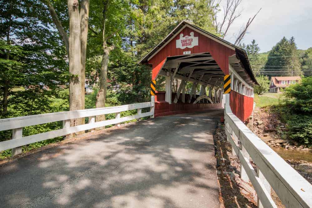
Shaffer’s Covered Bridge is the northernmost covered bridge in Somerset County and is located near Johnstown, PA.
This covered bridge was constructed in 1877. It is normally open to traffic but is closed as of December 2019 as it awaits needed repairs before it can be reopened.
Shaffer’s Covered Bridge crosses Ben’s Creek and is sometimes known as Ben’s Creek Covered Bridge. It is 68 feet long.
Despite being located near a busy road and in a residential area, this is a very beautiful setting for a covered bridge.
Getting there: Shaffer’s Covered Bridge located in northern Somerset County only about 15 minutes from downtown Johnstown, PA. It can be found at the following coordinates: 40.281261, -78.964131.
Until repair work is completed on the bridge, parking here will likely be tricky. There is, however, room to park a car on the southern end of the bridge during normal times.
Looking for even more spots to explore in the Laurel Highlands? Check out the Quecreek Mine Rescue Site, Yoder Falls, Kooser State Park, and the highest mountain in Pennsylvania.
[Click here for information on how to use the coordinates in this article to find your destination.]
 "
"