

Located in Northwestern Pennsylvania, Oil Creek State Park is one of the most historic areas of the state. It was in the valley, just outside of the park grounds that Edwin Drake drilled the world’s first commercial oil well at what is now known as the Drake Well Museum.
Throughout the land that is now Oil Creek State Park, oil boomtowns popped up and the landscape was forever altered by the thousands of oil pumps that were scattered throughout the land. Today, however, Oil Creek State Park is one of the most natural state parks that I’ve visited. And, scattered throughout the park are four named waterfalls including Pioneer Falls and Plum Dungeon Falls.
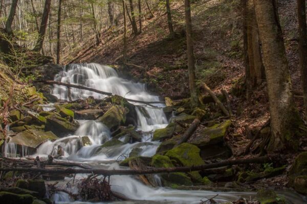
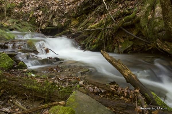
Probably the easiest of these four waterfalls to reach is Miller Falls. Located just a few hundred yards off the road along a marked trail, Miller Falls is definitely an interesting waterfall to visit.
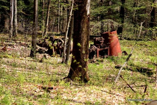
Miller Falls is located just off of the Gerard Hiking Trail, a trail that runs 36 miles through the park. The path is fairly level and easy as it travels a few hundred yards to the top of Miller Falls. Along the way, you’ll pass a pile of old, rusty oil equipment that harkens back to the time when the area was experiencing its oil boom.
Fortunately, someone has strung up a very sturdy rope from the top of the falls to the bottom. I’m not the lightest guy, and I had to put my full weight on the rope on more than one occasion, so I can personally attest to the rope’s strength. However, the rope should obviously be used at your own discretion and I was told by a park ranger that it wasn’t set up by the park.
Once you reach the bottom of the falls, where a large piece of old oil equipment sits, you will still have a difficult time seeing the falls. Unfortunately, getting the best view of the falls requires you to get your shoes a bit wet. Fortunately, though, even during high water, the stream at the bottom of Miller Falls is no more than a foot or so deep.
For photographers, the area around Miller Falls can be difficult to shoot because of the way the light streams through the trees. However, I would imagine my shots would have come out nicer had I been able to visit outside of mid-day.
It’s also worth noting that the trip back up the steep embankment was even more challenging than the trip down. I had to rely fully on the rope on several occasions and felt more like I was rock climbing than hiking.
Had it not rained heavily the night before, the solid ground might have made things a bit easier, but it still would have been a bit of a challenge. Because of this, I would recommend only the fittest and sure-footed attempt the trip to the bottom of the falls.
The small pull-off area for Miller Falls is located along Miller Farm Road at approximately the following GPS coordinates: 41.575530, -79.653155. Parking is just downhill of the trailhead.
Want to see more of Pennsylvania’s best waterfalls? Check out our Pennsylvania Waterfalls page!
[Click here for information on how to use the coordinates in this article to find your destination.]
 "
"


I love exploring beautiful Pennsylvania!!!
There is relatively easier way to the bottom of the falls. Park at the next little parking spot down hill from the miller falls sign and follow the path there. It has stairs built in. At the bottom walk to the left maybe 10 yard along the paved bike/walking path. Miller’s run (at least that’s what i think it’s called) will be on the left. Creek-walk it maybe a couple hundred yard to the base of the falls. There’s some interesting small cascades and the remains of a wooden water tower along the way. There is also a nice 4ish foot cascade about 50 to 70 yards above the falls.