Located near the center of the state, Lycoming County is both a popular travel destination and a common destination for those passing through north-central Pennsylvania.
Lycoming County is Pennsylvania’s largest county, nearly 10 times the size of Montour County, the state’s smallest county. So, it should come as little surprise that the covered bridges of Lycoming County are spread out over a sizable distance. However, don’t let the driving time to some of these bridges deter you from visiting them.
The bridges in the county, especially the two rural ones, are quite picturesque and well worth visiting.
The bridges here are listed north to south, primarily because the northernmost bridge is the most accessible of the three covered bridges in Lycoming County. If you are looking for further adventure beyond these covered bridges, I’ve included a few suggestions at the bottom of this article.
Buttonwood Covered Bridge
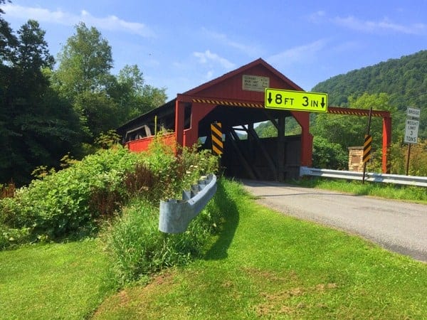
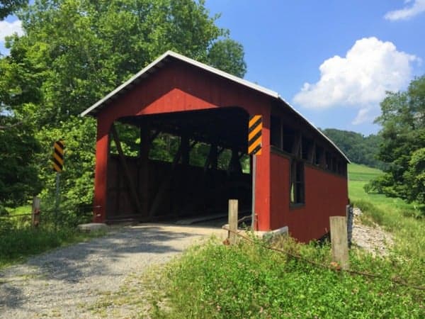
Buttonwood Covered Bridge is located along Route 15 in northern Lycoming County, just a few miles south of Tioga County. Buttonwood Covered Bridge is roughly 70-feet long (sources say 63 feet or 74 feet) and crosses Blockhouse Creek. It was likely built in 1898, but some sources list an earlier date. The bridge was refurbished in 1998, and it is possible to drive through the bridge.
Despite being in a fairly rural area and being located along a dirt road, the bridge’s location next to a sawmill and Route 15 give the area an industrial feel. Nevertheless, Buttonwood Covered Bridge is quite striking.
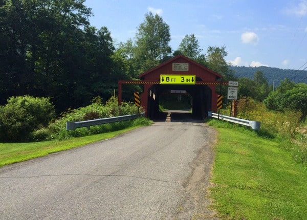
Getting There: Buttonwood Covered Bridge can be seen from Route 15 North, but there is no access to the bridge directly from the highway. The best option is to take the exit south of the bridge onto Route 284. The bridge is located only about a mile off the road, making for a short detour.
Buttonwood Covered Bridge can be found at the following coordinates: 41.509905, -77.130091. If the sawmill is closed, it may be possible to park in the corner of their lot, but otherwise, there are few places at the bridge to pull off. While possible, it is not recommended to pull off to the side of 15N to photograph the bridge.
Cogan House Covered Bridge
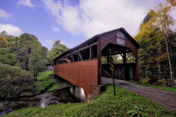
Cogan House Covered Bridge (also known as Buckhorn Covered Bridge) is one of the most rural covered bridges I’ve visited in Pennsylvania. Its location, far from any major roads, means that you’ll have to make a point to visit this bridge. It’s very unlikely that you’ll be traveling close to this bridge at any time. However, the rural setting for this bridge makes it one of the more peaceful covered bridges you’ll find in Pennsylvania.
Cogan House Covered Bridge crosses Larrys Creek, a tributary of the West Branch of the Susquehanna River. The bridge is 94-feet long, was built in 1877, and is the oldest and longest covered bridge in Lycoming County. Interestingly, it was the only bridge on Larrys Creek to survive the June 1889 storm that caused the Johnstown Flood.
Getting There: Cogan House Covered Bridge is located in northwestern Lycoming County, roughly halfway between Route 15 and the Pennsylvania Grand Canyon. It is just north of State Game Lands 114, and the entrance to the public property provides a bit of room to park. The bridge can be found at the following coordinates: 41.398288, -77.200506.
It’s worth noting that while it is possible to drive across the bridge, the land just beyond the bridge is posted as private property.
Lairdsville Covered Bridge
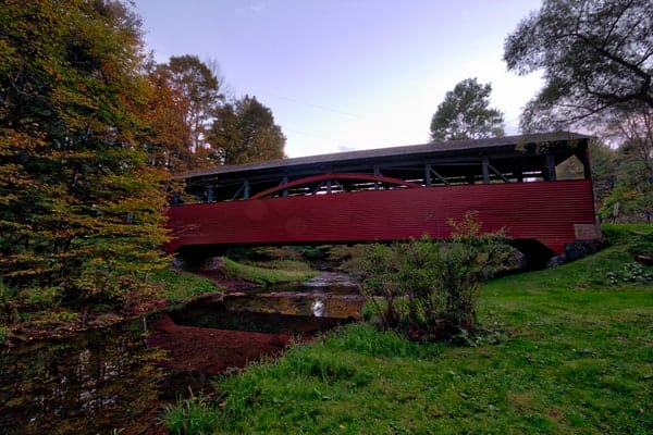
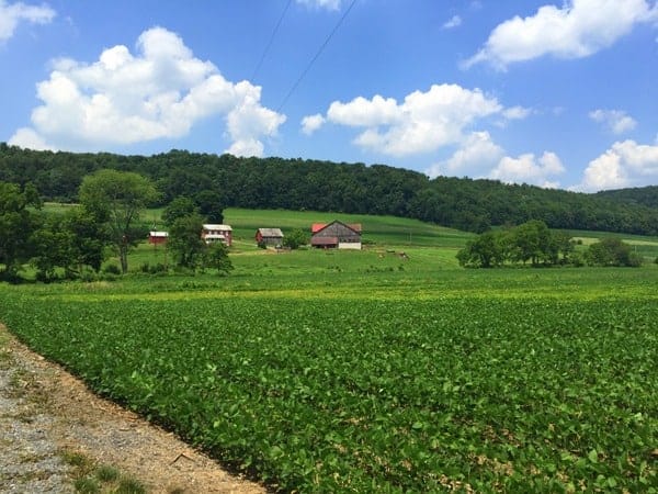
Lairdsville Covered Bridge (also known as Moreland Covered Bridge or Fraser Covered Bridge) is located in southeastern Lycoming County. It is located in Moreland Township, though the closest decent sized community is Muncy, 20 minutes away.
Lairdsville Covered Bridge is located in one of the most beautiful spots I’ve seen for a covered bridge. The bridge is located in a wide valley, surrounded by beautiful farms and rolling hills. Take some time to really appreciate the bridge’s setting while you are here.
The bridge crosses 78 feet over Little Muncy Creek and was built in 1888. It is located at the end of a dirt road, and while it has seen better days, it is still possible to drive across the bridge.
Getting There: Lairdsville Covered Bridge is located in a rural part of southeastern Lycoming County, roughly 50 miles from the other covered bridges in the county. It can be found at the following coordinates: 41.207247, -76.635748.
While you can still drive over the bridge, the far side of the bridge only contains a fenced-in area to turn around. However, this area is your best bet for parking, and there is ample space for multiple cars to park here.
Options for Further Exploration
Those looking for further adventures behind these bridges can continue north to Wellsboro and the Pennsylvania Grand Canyon for the northern bridges. If you want to see more covered bridges, the westernmost bridge in Columbia County (Shoemaker Covered Bridge) is only about 20 minutes from Lairdsville Covered Bridge. Or, in 35 minutes, you can get to the last covered bridge in Montour County or the northernmost covered bridge in Northumberland County (Sam Wagner Covered Bridge).
[Click here for information how to use the coordinates in this article to find your destination.]

The closest decent sized community to the Lairdsville Bridge happens to be Hughesville, which is approximately 5 minutes away, at the intersection of Rt 118W and Rt 405.
To visit the Lairdsville Bridge from Hughesville, one would travel East on Rt 118 aprox. 5 miles, turn right onto Dairy Farm Road, just past Tome Road at the barn turn left onto Covered Bridge Road. A very short distance ahead you will see the bridge.
A lovely place to visit in the summertime.
Was born and raised in Marsh Hill, Lycoming County and would enjoy these newsletters!
Like to find out info on a old long gone covered bridge called Pocono bridge in Muncy went accross Muncy creek any one know any thing about it.
I don’t, but the Muncy Historical Society does a great job and might have some information for you.